GIS Transport Services
 |
 |
 |
 |
 |
 |
GIS transport is one of the leading GIS application fields. We have implemented Many GIS transport applications that cover much of the broad scope of transportation and logistics, such as infrastructure planning and management, transportation safety analysis, travel demand analysis, traffic monitoring and control, public transit planning and operations, environmental impacts assessment, intelligent transportation systems (ITS), routing and scheduling, vehicle tracking and dispatching, fleet management, site selection and service area analysis, and supply chain management.
As a transportation professional, you need the most cost-effective tools to manage physical assets, human resources, and office and field operations. GIS can help you plan, monitor, and manage strategic infrastructure more effectively. Use the location power of your data to determine capacity enhancements, improve operations, and identify the most strategic investments for maintaining your transportation infrastructure. GIS can make your stand-alone systems work smarter by connecting them, allowing you to unlock the power of your information systems. Plan a smarter infrastructure today.
-
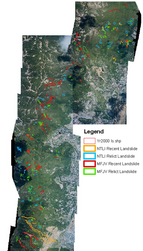
Natural Terrain Hazard Mapping & Landslide Susceptibility Map
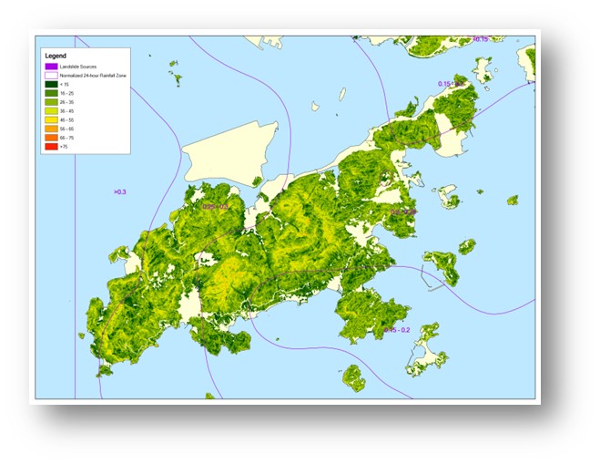
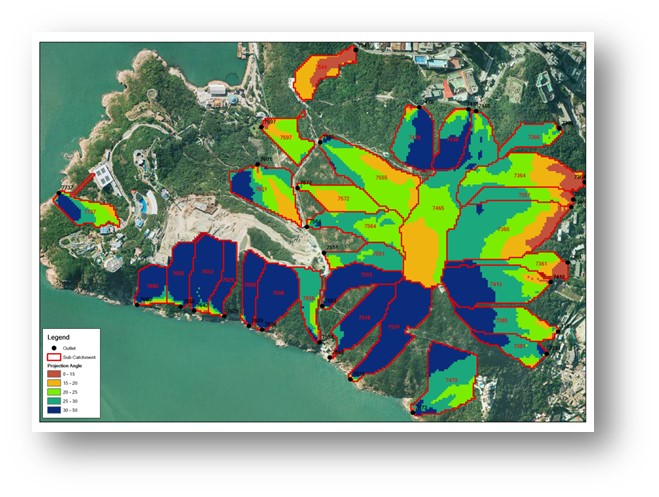
The rainfall data is the raw data for this analysis. The generated maximum rolling 24 hours result by the rainfall data is used in ArcGIS for Geostatistical Analysis. Rainfall class is then generated in this process for spatial correlation analysis.
With adding the man made slope and landslide incident layers, GIS has the capability to transfer and combine the rainfall classes, number of landslides, number of man-made slopes in different types into 1600 grids of entire Hong Kong Coverage.
The correlated result is stored in shapefiles format which can be extracted directly to excel format for further regression analysis. A relationship between the amount of maximum rolling 24 hours rainfall and landslide frequency is further established by the regression analysis.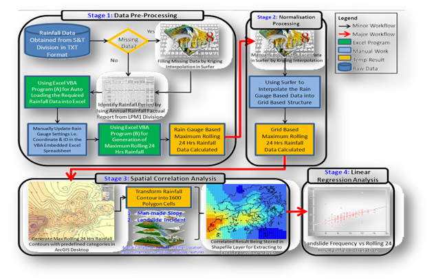
Using digital topographic data i.e. spot height or contour map, which obtains from national mapping organisation, our GIS application can derive Digital Elevation Model (DEM), curvature, aspect and slope gradient of the study area.
DEM is generated by the application, and then being used for deriving those other’s topological analysed products.
Our GIS application can auto generate result in according to user specified slope gradient categories and the defined study boundary. Using the recognized geological analyzing approach from GEO, it categorises terrain into 7 major classes, each assign with distinctive colour scheme for presentation.
It has significantly improved efficiency on terrain analysis work for geologists, for those used to take hours of efforts can now finished within seconds.
-
Displaying & Analysis of Environmental Expert Model - Traffic Noise Modelling
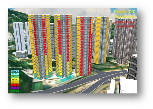
Traffic noise analysis is one of the key environmental issues in most of developed cities. Using GIS and traffic noise expert modelling system i.e. CadnaA or LimA; 2D and 3D noise maps are developed for high level spatial analysis.
GIS is being used for pre-processing spatial data to form landscape model as a base for computation in noise expert system. Modelled results were then being post-processed by GIS for online 3D publishing in VRML or through 3D GIS application, for example Skyline.
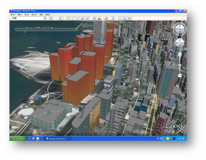
The modelled noise results can be presented by 3m x 3m façade attached on building surface. One of the way is by using the Google Earth freely available 3D rendering engine, those modelled noise results can be illustrated in dynamic 3D approach, which is similar to real world traffic noise distribution phenomena.
-
Over Decade of Success Story - Industry Leading GIS Application – Pioneering in the Year of 2001 – Tsing Shan NTHS
Using digital topographic data i.e. spot height or contour map, which obtains from national mapping organisation, our GIS application can derive Digital Elevation Model (DEM), curvature, aspect and slope gradient of the study area.
DEM is generated by the application, and then being used for deriving those other’s topological analysed products.
Our GIS application can auto generate result in according to user specified slope gradient categories and the defined study boundary. Using the recognized geological analyzing approach from GEO, it categorises terrain into 7 major classes, each assign with distinctive colour scheme for presentation.
It has significantly improved efficiency on terrain analysis work for geologists, for those used to take hours of efforts can now finished within seconds.