-
What is a Geographic Information System (GIS)?
 What is a Geographic Information System (GIS)?A GIS is a computer system capable of assembling, storing, manipulating and displaying geographically referenced information, i.e. data identified according to their locations. A GIS combines layers of information about a location to give a better understanding of that place....
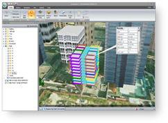
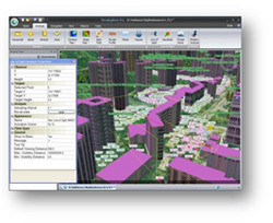
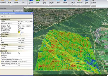
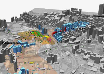
A GIS is a computer system capable of assembling, storing, manipulating and displaying geographically referenced information, i.e. data identified according to their locations. A GIS combines layers of information about a location to give a better understanding of that place. What layers of information the system combines depend on the user’s purpose – finding the best alignment for a proposed highway, analysing environmental impact, viewing similar crimes in a city to detect patterns, presenting the 3D landscape model for urban planning, exploring the landslide susceptibility of a region, and so on.
-
What is the requirement for the data of GIS?
What is the requirement for the data of GIS?A GIS can use information from different sources i.e. typical relational database, satellite images, aerial photos, CAD or even Excel data files. The primary requirement for the source data is that the locations for the variables are known. Locations may be annotated by x, y ...
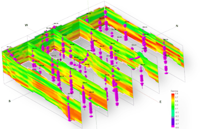
A GIS can use information from different sources i.e. typical relational database, satellite images, aerial photos, CAD or even Excel data files. The primary requirement for the source data is that the locations for the variables are known. Locations may be annotated by x, y and z coordinates of longitude, latitude and elevation. Any variable that can be located spatially can be fed into a GIS.
-
Why GIS can Improve Organisational and Data Integration?
Why GIS can Improve Organisational and Data Integration?One of the main benefits of a GIS is the improvement in management of organisation and resources. A GIS can link datasets together using common locational data, such as coordinate readings or addresses, which helps departments and agencies share their data. By creating a shar...
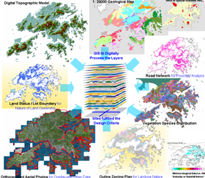
One of the main benefits of a GIS is the improvement in management of organisation and resources. A GIS can link datasets together using common locational data, such as coordinate readings or addresses, which helps departments and agencies share their data. By creating a shared database, departments can benefit from the work of others – data can be collected once and used many times.
-
Why GIS can Make Better Decisions?
Why GIS can Make Better Decisions?“Better information leads to better decisions” which is true for GIS. A GIS is not just an automated data viewing system but a tool to query, analyse and map data in support of the decision making process. For example, GIS can be used to help reach a decision about the locati...
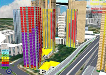
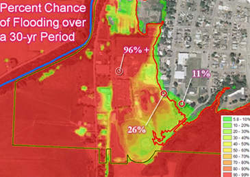
“Better information leads to better decisions” which is true for GIS. A GIS is not just an automated data viewing system but a tool to query, analyse and map data in support of the decision making process. For example, GIS can be used to help reach a decision about the location of a new housing development that has minimal environmental impact, is located in a low-risk area and is close to a transport hub. The information can be presented clearly on a map and accompanying report, allowing decision makers to focus on the real issues rather than trying to understand the data. Because GIS products can be generated quickly, multiple scenarios can be evaluated efficiently and effectively.
-
Why GIS is so popular?
Why GIS is so popular?Very often people say “I see” to mean “I understand”. Pattern recognition is something human beings excel at. There is a vast difference between seeing data in a table of rows or columns and seeing it presented in the form of a map. The difference is not simply aesthetic, it ...
Very often people say “I see” to mean “I understand”. Pattern recognition is something human beings excel at. There is a vast difference between seeing data in a table of rows or columns and seeing it presented in the form of a map. The difference is not simply aesthetic, it is conceptual – it turns out that the way people see their data has a profound effect on the connections and conclusions that they can make from it. GIS gives users the layout and drawing tools that help present facts with clear and compelling documents.
-
AMBIT’s GIS Consultancy Service
AMBIT’s GIS Consultancy ServiceAMBIT is one of best independent geospatial consultant companies, having developed a tradition of excellence in successfully providing quality professional services to government authorities and a broad range of industries throughout Hong Kong and internationally. AMBIT has u...
AMBIT is one of best independent geospatial consultant companies, having developed a tradition of excellence in successfully providing quality professional services to government authorities and a broad range of industries throughout Hong Kong and internationally. AMBIT has used GIS for a wide variety of clients ranging from multi-national companies, financial institutions, to government departments and has developed a keen awareness of each client’s individual needs and expectations.
-
We are a solution provider who not only knows how but also knows why……
We are a solution provider who not only knows how but also knows why……Creation of a good GIS relies not only on developer’s experience but also on his recognition to the users’ workflows, characteristics of client’s data structure and capabilities of different GIS vendors’ strength. AMBIT first found its way to GIS as a user. Throughout the yea...
Creation of a good GIS relies not only on developer’s experience but also on his recognition to the users’ workflows, characteristics of client’s data structure and capabilities of different GIS vendors’ strength. AMBIT first found its way to GIS as a user. Throughout the years our GIS team has worked together with different engineering expertise to serve clients from various government departments, using our cutting edge GIS technology. The team has greatly contributed to our multi-disciplinary engineering consultancy services and it has become spatial solution provider. With decades of success in multi-disciplinary engineering services as well as proven records on the application of geomatics technology in engineering and environmental industries, we can resolve any client’s spatial problem by our professional knowledge.
 “We are a solution provider who not only knows how but also knows why……”