
TerraExplorer - Bring the digital planet to your home or office.
|
With Skyline's TerraExplorer, users can navigate through high resolution 3D world environments created by fusing aerial and satellite photography, terrain elevation data and other 2D and 3D information layers. After installation, TerraExplorer Viewer can be run as a stand-alone application, providing standard capabilities, or it can serve as the SkylineGlobe viewer embedded in a SkylineGlobe web package, providing advanced API capabilities.
|
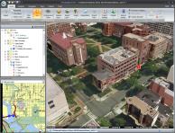 |
View all terrain data and terrain overlays created with TerraExplorer Pro and TerraBuilder
With TerraExplorer, users can navigate through high resolution 3D world environments. TerraExplorer Viewer efficiently streams photo-realistic terrain data and terrain overlay information over any network.
Set the appearance of the environment in the 3D Window
Enhance the realism of your 3D environment by controlling settings such as horizon distance, fog color, and sun and moon display. Preset or custom sky textures and colors can be applied and animated cloud layers can be displayed over the entire terrain, with customized altitude, position, density, and movement settings. Reflection and movement effects can be displayed on all sea and ocean terrain.
Preset or custom sky textures and colors can be applied. An animated cloud layer can be displayed over the entire terrain, with customized altitude, position, density, and movement settings. Reflection and movement effects can be displayed on all sea and ocean terrain.
Measure and analyze your terrain
TerraExplorer provides a set of tools for measurement of horizontal, aerial, and vertical distance, as well as advanced tools for measurement and terrain analysis, including Line of Sight, Viewshed, 3D Viewshed, Threat Dome, Shadow Analysis, Flood Analysis, and Volume Analysis.
Integrate TerraExplorer into your own application or website
TerraExplorer can operate as a stand-alone application or you can use TerraExplorer’s powerful API to integrate TerraExplorer ActiveX controls within your own application or website.
Share screenshots with others who don’t have TerraExplorer Viewer
TerraExplorer Viewer allows you to save screenshots in BMP or TIFF format, so that you can use them to easily portray complex spatial relationships.
Share geographical information with others through dynamic presentations
TerraExplorer provides a powerful tool for creating and sharing photo-realistic presentations of any 3D environment. In presentation mode, you can record your navigation through the 3D World, determining in each presentation step the precise view in the 3D Window - what layers, objects, and messages are displayed, what tools are opened, and the current date and time. Routes can be created in the way you find most efficient and intuitive using any of the flexible available options, including flying through the terrain recording an exact route, adding sequential location waypoints, and following a dynamic object. An easy to use editor enables you to set step timings and transitions and modify step sequence.
A movie in AVI format can be created from any presentation in your project. This movie can then be played using a standard AVI Viewer or any product that supports AVI format or multi frames format, or even displayed on a TV screen.
Troubleshoot and keep track of core functionality events
The TerraExplorer log records and displays warnings, messages, and errors.